Publisher's Synopsis
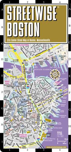
REVISED DEC 2017 Streetwise Boston Map is a laminated city center map of Boston, Massachusetts. The accordion-fold pocket size travel map has integrated trolley lines & MBTA subway map. Coverage includes: Main Boston Map 1:23,000 Downtown Boston Map 1:17,000 Boston Regional Map 1:507,000 Boston Rapid Transit Map (MBTA Subway & Trolley Stations). Dimensions: 4" x 8.5" folded, 8.5" x 27" unfolded Navigate your way to the highlights of this historic yet lively city. Take in a Red Sox game at Fenway Park, retrace the past on the Freedom Trail, visit an art museum, or enjoy dinner at one of North End's traditional Italian restaurants. The STREETWISE¬ Boston city map is the ultimate aid for getting around New England s largest city, featuring a manageable yet intricately detailed layout of the entire city from the North End to Fenway, Brookline and Allston, across the river to Cambridge, and back through East Boston. The STREETWISE¬ Boston map also provides a complete map of the city of Boston's public transportation options. The MBTA subway and trolley MINI METRO map covers all stops on the Green, Red, Orange, Blue, and Silver T lines. Our pocket size map of Boston is laminated for durability and accordion folding for effortless use. Explore more of Boston by checking out the Michelin Green Guide to New England. For driving or planning your trip to and from Boston, use the Michelin New England/Hudson Valley Map No. 581.