Outer Hebrides Pocket Map

Outer Hebrides Pocket Map The Perfect Way to Explore the Western Isles

Sheet Map (folded) (07 Feb 2019)

Not available for sale

Includes delivery to the United States

Out of stock

This service is protected by reCAPTCHA and the Google Privacy Policy and Terms of Service apply.

Publisher's Synopsis

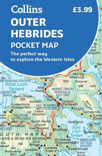
Explore new places with handy pocket maps from Collins.Handy little full colour map of the Western Isles of Scotland. Detailed mapping and tourist information for the islands of Lewis, Harris, Uist, Benbecula, Barra and St Kilda. Excellent value and very detailed for its size.Main features of this map include:• Clear mapping at a scale of 3.2 miles to 1 inch• Tourist attractions located and described• Ideal for touring with sights, places to stay, cafe/restaurant, things to do all on the map• Transport links map showing how to get to and depart the islands• Index to places of interest and place namesEssential for those planning a trip around the Western Isles.

About the Publisher

Collins

Collins

Collins has been publishing educational and informative books for almost 200 years. Throughout this rich heritage we have maintained an impressive record in creating market-leading products across various sectors.

Book information

ISBN: 9780008325466
Publisher: HarperCollins Publishers
Imprint: Collins
Pub date:
Language: English
Number of pages: 2
Weight: 30g
Height: 127mm
Width: 90mm
Spine width: 6mm