Oregon Coast South, or No. 656Sx

Oregon Coast South, or No. 656Sx

Sheet Map (folded) (16 May 2023)

Not available for sale

Includes delivery to the United States

Out of stock

This service is protected by reCAPTCHA and the Google Privacy Policy and Terms of Service apply.

Publisher's Synopsis

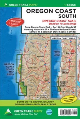
22.5 inch x 30 inch unfolded (shipped folded, 6 x 9) waterproof, tear resistant, ultralight map printed on Polyart.

Areas covered:

  • Cape Blanco State Park
  • Port Orford Heads State Park
  • Humbug Mountain State Park
  • Siskiyou National Forest
  • Samuel H. Boardman State Scenic Corridor
As every experienced backcountry adventurer knows, possessing solid tools for navigation is one of the Ten Essentials for a safe adventure. There are, of course, many technological options out there, but to truly be prepared there's really nothing better than a paper map--and there's absolutely no better map than a color topographic Green Trails map. Fully vetted and high quality, Green Trails maps are not only useful for trip planning but will keep backcountry travelers on track, long after the batteries have died on other navigational devices.Context counts

Each map includes:

  • Trails coded for hikers only, as well as mountain bikers, stock, skiers, and snowmobilers
  • Icons for parking and picnic areas, tent camping and RV spaces, bathrooms and backcountry toilets, points of interest, waterfalls, springs, and gates
  • Dot-to-dot trail distances, contour intervals, adjacent map numbers, and permits required
  • Land designations: national and state parks, national forest, wilderness, DNR land, private land, tribal land, and others

Book information

ISBN: 9781680515954
Publisher: Mountaineers Books
Imprint: Green Trails Maps
Pub date:
Language: English
Number of pages: 2
Weight: -1g
Height: 229mm
Width: 152mm
Spine width: 0mm