Publisher's Synopsis
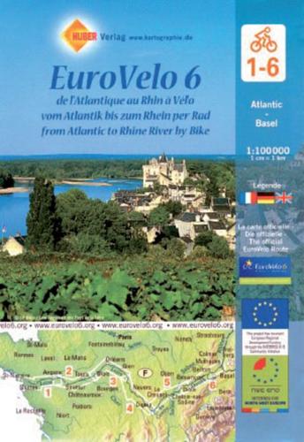
EuroVelo Route No. 6 in a six-map set covering the French part of this trans-European cycle route: from the Atlantic along the Loire, the Canal du Centre, the Saone, the Doubs and the Canal du Rhone au Rhin to the Rhine at Basel. The route is presented on six double-sided, GPS compatible maps at 1:100,000 published by Huber Verlag with funding from the European Union. The overprint highlighting the route and its variants indicates traffic-free sections, roads with heavy motorized traffic, different types of surface and gradients, as well as intermediate and cumulative distances. For larger towns detailed street plans are provided including, where appropriate, alternative routes across their centres (Nantes, Angers, Tours, Orleans, Nevers, Chalon-sur-Saone, Besancon, Mulhouse and Basel). Exceptionally clear cartography, with relief shading and spot heights to show the topography, presents the road and rail networks of the surrounding countryside. Symbols highlight various places of interest including cycle repair and/or rental, campsites and youth hostels, tourist information offices, sport and recreational facilities, museums, etc. The maps have a 5-km UTM grid for GPS users. Map legend includes English. Our maps are regularly updated even if the ISBN does not change. (Edition updated in 2017).