Publisher's Synopsis
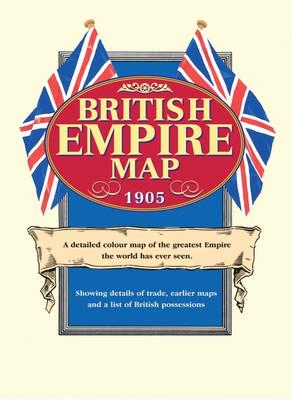
As the twentieth century dawned the British Empire enjoyed its heyday. It spanned 11 million square miles with 400 million inhabitants. This detailed colour reproduction of a contemporary world map shows details of global trade including the furs of fox, bear, seal and otter brought from the shores of Canada's Lake Athabasca by canoes in summer and dog sleds in winter; cochineal, indigo & vanilla from central America; teak and bamboo from Siam; cinnamon and pearls from Ceylon; tortoise shells & birds of paradise from New Guinea as well as minerals and foodstuffs from all over the world. In the Sahara we note that slaves were still traded. Coaling stations, telegraph cables, railways and caravan routes are all marked. Additional maps show the development of the Empire in the preceding three centuries. A ten page gazetteer describes over 200 British countries and possessions, as well as 33 (including Normandy and the USA) which had been lost to the crown. Folded in a protective wallet.