Delivery included to the United States

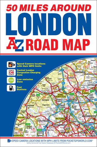
50 Miles Around London A-Z Road Map

50 Miles Around London A-Z Road Map

New Eighth edition

Sheet Map (folded) (25 Nov 2015)

Not available for sale

Out of stock

This service is protected by reCAPTCHA and the Google Privacy Policy and Terms of Service apply.

Publisher's Synopsis

This A-Z 50 Miles around London map is a full colour, single sided road map featuring continuous mapping extending from Rugby and Bury St. Edmunds to the south coast and from Oxford and Winchester to Margate and Felixstowe in the east.Published at a clear 3.5 miles to 1 inch the following features are shown on the road mapping:•Motorways open with full junction detail, motorways under construction and proposed, service areas, primary routes and destinations, A & B roads, selected minor roads, gradients 1:5 and steeper, tolls, mileages, county boundaries, spot heights and hill shading•Selected safety camera locations with maximum speed limits•Selected fuel stations•A wide range of ancillary and tourist information•South Downs National Park boundaryAn index to cities, towns, villages, hamlets and locations is adjacent to the map.
About the Publisher

Geographers' A-Z Map Co Ltd

Started in 1936 as Geographers' Map Company Ltd, we are now the largest independent map publishing company in the UK, producing iconic products such as the London A-Z. We produce over 340 mapping products and employ 80 staff, many of whom joined from school, and have been with the Company for over 25 years. Our founder, Phyllis Pearsall MBE, gave us a motto- "ON WE GO" and as a team we can, and will, do just that, providing high quality mapping products and priding ourselves on customer satisfaction.

Book information

ISBN: 9781782571087
Publisher: HarperCollins Publishers
Imprint: Geographers' A-Z Map Co Ltd
Pub date:
Edition: New Eighth edition
Language: English
Number of pages: 1
Weight: 140g
Height: 234mm
Width: 160mm
Spine width: 10mm