Publisher's Synopsis
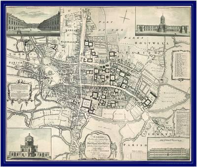
One of the nation's most recognisable historic cities, Oxford has upheld its reputation as a cultural and academic centre for centuries. This map, published in 1789, immortalises a city as yet untouched by the industrialisation that brought first the canal system (in the 1790s) and the Great Western railway (1844). Dominated by the medieval university colleges and the winding of the Thames, the eighteenth-century landscape offers an antiquated yet familiar snapshot of the city, including detail such as students' social haunts, churches, university buildings and prisons. This attractive depiction of one of Britain's most historic cities is an invaluable tool for local historians and genealogists, as well as those interested in its royal and academic connections.