Publisher's Synopsis
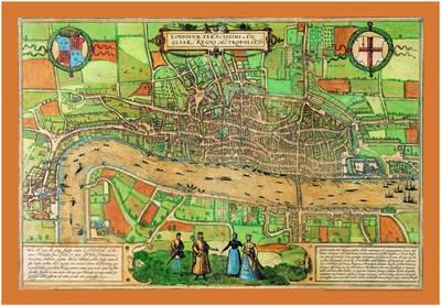
The earliest entirely extant city plan of London, this map of the Elizabethan capital was first printed in 1572. As well as being a beautiful decorative piece, it also offers an invaluable insight into the geography of London and lives of its inhabitants. It features the infamous Tower of London, a bear baiting arena, the Charterhouse monastry, the monument at "Chary-ncros", Old St Paul's Cathedral and even local wildlife in the grassy fields north of Holborn.