Collins Children's World Wall Map

Collins Children's World Wall Map An Illustrated Poster for Your Wall

Second edition

Sheet Map (rolled) (16 May 2019)

Not available for sale

Includes delivery to the United States

Out of stock

This service is protected by reCAPTCHA and the Google Privacy Policy and Terms of Service apply.

Publisher's Synopsis

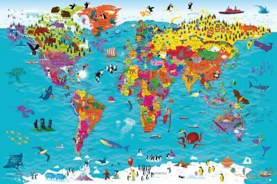
Beautifully illustrated wall map for inquisitive kidsColourful Illustrated Map of the WorldThis bestselling, highly illustrated pictorial map is designed to take children on a journey of discovery around the countries of the world. The mapping is up-to-date, colourful and highly informative and shows countries and capital cities.Stunning illustrations are used to depict themes such as national emblems, customs, food, birds, animals, buildings and sports to help younger readers gain an understanding of the world.Dimensions 610 X 915 mm / 24 x 36 inchesIllustrated by Steve Evans.Now with barcode removed due to popular demand from our customers.

About the Publisher

Collins

Collins

Collins has been publishing educational and informative books for almost 200 years. Throughout this rich heritage we have maintained an impressive record in creating market-leading products across various sectors.

Book information

ISBN: 9780008319793
Publisher: HarperCollins Publishers
Imprint: Collins
Pub date:
Edition: Second edition
Language: English
Number of pages: 1
Weight: 96g
Height: 917mm
Width: 30mm
Spine width: 30mm