Publisher's Synopsis
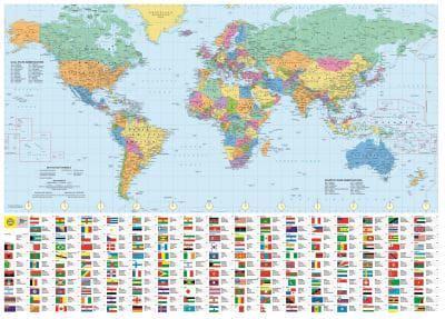
Clear and packed with the latest data, this stylish, politically-coloured map will grace any wall.Whether planning global expansion in business, your next adventure holiday, or resolving an argument about the capital of South Korea, this world wall map provides the perfect solution. Gorgeous to look at and packed with information including national flags, this easy-to-read large poster map will look fabulous on the wall of any home, school or office. Generously sized at 1070 x 770mm. In association with the Royal Geographical Society, Philip's have collated in one place everything you need to plan your holiday travels, international export routes or just remind yourself just how enormous Kazakhstan really is. Clear, at-a-glance data with the latest on flags, capital cities, currencies, population and area statistics, and time zones for every major country in the world.Perfect as a gift, but also a highly practical self-purchase, this edition of Philip's Royal Geographical Society World Wall Map is supplied laminated for hard-wearing use and durability, all rolled into a sturdy colourful cardboard box.